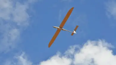
An Indian startup in collaboration with a state-run defense manufacturer is developing a solar-powered surveillance drone that can cruise at an altitude of up to 65,000 feet (19,812 meters), NDTV reported.
The drone, named Infinity, is being developed as part of India’s CATS (Combat Air Teaming System) unmanned drone warfare program with an eye on China, and could be deployed in three to five years.
Infinity is being designed to remain airborne in the stratosphere for up to 90 days at a stretch, where it will be able to keep track of targets deep within enemy territory using synthetic aperture radar.
In the Making for Over Three Years
NewSpace, a Bengaluru based start-up, has had the drone in the making for more than three years. It was first conceptualized as a long endurance, cheaper alternative to surveillance satellites, which run out of fuel much faster.
Speaking to NDTV in December 2017, developers told the outlet that the unmanned aerial platform uses a variety of pods to beam still or moving images day or night “through infrared (night-vision) or hyperspectral imagery.”
Will Work With Other Hunter Drones
Fast forward to 2021, and Infinity is now part of the CATS program where it is envisioned as keeping tabs deep inside enemy territory and coordinating with other manned and unmanned systems of the program such as the Warrior “loyal wingman,” Alfa-S swarm drones, or Hunter cruise missiles.
The program has been spearheaded by Hindustan Aeronautics Ltd, a state-run aircraft maker, under which Infinity is also being prepared to be able to capture and relay video feed of future air operations involving the other combat platforms.
The video will be used to confirm military evaluation of combat situations and analyze operations after they have taken place.
Infinity also has a variety of civilian functions, including providing images and video for disaster operations management, natural resource management, and monitoring coastal waterways.